PICTURES ARE LOADING...
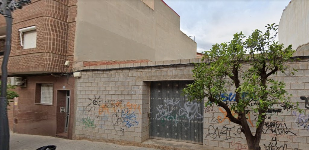
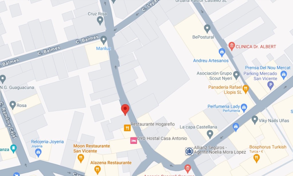

Land for sale in San Vicente del Raspeig / Sant Vicent del Raspeig
USD 214,053
Land (For sale)
1,950 sqft
Reference:
EDEN-T95558089
/ 95558089
Reference:
EDEN-T95558089
Country:
ES
City:
Alicante San Vicente Del Raspeig
Postal code:
3690
Category:
Residential
Listing type:
For sale
Property type:
Land
Property size:
1,950 sqft
REAL ESTATE PRICE PER SQFT IN NEARBY CITIES
| City |
Avg price per sqft house |
Avg price per sqft apartment |
|---|---|---|
| Alicante | USD 305 | USD 274 |
| Alicante/Alacant | USD 282 | USD 297 |
| Mutxamel | USD 178 | USD 131 |
| Busot | USD 204 | - |
| Elche | USD 138 | USD 157 |
| Aspe | USD 152 | - |
| Santa Pola | USD 243 | USD 277 |
| La Vila Joiosa | - | USD 402 |
| Crevillent | USD 120 | - |
| Sax, Alicante | USD 92 | - |
| El Fondó de les Neus | USD 125 | - |
| Finestrat | USD 350 | USD 293 |
| Catral | USD 155 | - |
| San Fulgencio | USD 246 | - |
| Salinas | USD 104 | - |
GEOMETRY. The geometry of the site is rectangular.
TOPOGRAPHY. The topography of the site is flat.
INFRASTRUCTURE:
STREETLIGHT. Yes.
SEWER SYSTEM. Yes.
WATER SUPPLY. Yes.
POWER SUPPLY. Yes.
TELEPHONE NETWORK. Yes.
ROAD PAVING. Yes.
URBAN DESCRIPTION:
URBAN PLANNING
GENERAL PLANNING. General Municipal Plan of Urban Planning of San Vicente del Raspeig.
APPROVAL PHASE. Definitively approved in 1989.
DEVELOPMENT PLANNING. It is not recorded. As part of the General Plan, the planning of this area of the city is regulated by the "Traditional Centre" Ordinance. FURTHER PLANNING. It is not recorded.
CLASSIFICATION URBAN1STICA.
Consolidated Urban Land. CT-1a.
Traditional Helmet, Grade 1, Level A.
GENERAL PARAMETERS.
Characteristic use: residential, type of closed building, alignment to the façade, 100% occupancy, the maximum height would be PB + 1, but as there is an adjoining building of PB + 2, article 1.3.f. would be accepted, which reads as follows: If a plot adjoins laterally, on only one of its lateral boundaries, with a building of greater height on the façade, expressed in the number of floors, which the maximum authorized in application of the previous rules, may build more height next to said boundary, with the complementary conditions that this larger building does not have a depth greater than 12 meters from the boundary that causes it or that its lateral façade is less than 3 m from the opposite lateral boundary.
URBAN MANAGEMENT
SUBJECT. Promoter.
ACTION SYSTEM. Indirect management.
URBAN ENCUMBRANCES AND ASSIGNMENTS. There is no evidence of the existence of any urban planning charge. ELEMENTS AND PROCEDURES FINALIST SOIL. Currently, the floor, in view of the Regulations in force, is a finalist.
EXECUTION DEADLINES.
CADUCITY. Not applicable.
URBAN QUALIFICATION AND BUILDABILITY
CHARACTERISTIC APPLICATION. Residential.
SUPPORTED USES. Dotional. tertiary and industrial (except for the industrial production modality), on the ground floor and in an exclusive building.
PROHIBITED USES. They are not recorded.
AT THE MAXIMUM LEVEL. PB + 2. (Except in a strip of three meters wide separating it from the lowest boundary where the height will be PB+ 1).
CLASSIFICATION URBAN1STICA. Consolidated Urban Land. CT-1a. Traditional Helmet, Grade 1, Level A.
GENERAL PARAMETERS. Characteristic use: residential, type of closed building, alignment to the façade, 100% occupancy, the maximum height would be PB + 1, but as there is an adjoining building of PB + 2, article 1.3.f. would be accepted, which reads as follows: If a plot adjoins laterally, on only one of its lateral boundaries, with a building of greater height on the façade, expressed in the number of floors, which the maximum authorized in application of the previous rules, may build more height next to said boundary, with the complementary conditions that this larger building does not have a depth greater than 12 meters from the boundary that causes it or that its lateral façade is less than 3 m from the opposite lateral boundary.
URBAN MANAGEMENT
SUBJECT. Promoter.
ACTION SYSTEM. Indirect management.
URBAN ENCUMBRANCES AND ASSIGNMENTS. There is no evidence of the existence of any urban planning charge. ELEMENTS AND PROCEDURES FINALIST SOIL. Currently, the floor, in view of the Regulations in force, is a finalist.
EXECUTION DEADLINES. CADUCITY. Not applicable.
URBAN QUALIFICATION AND BUILDABILITY
CHARACTERISTIC APPLICATION. Residential.
SUPPORTED USES. Dotional. tertiary and industrial (except for the industrial production modality), on the ground floor and in an exclusive building.
PROHIBITED USES. They are not recorded.
AT THE MAXIMUM LEVEL. PB + 2. (Except in a strip of three meters wide separating it from the lowest boundary where the height will be PB+ 1).
- A basement floor for garages: 181.16 m2.
- Ground floor for two apartments: 181, 16 m2.
- First floor for two apartments: 181, 16 m2.
- Second floor for two dwellings (deducting the strip that we must leave three meters apart next to the lowest boundary): 134.51 m2.
Then the total buildable area (below ground and above ground) is: (181.16 m2 x 3) + 134.51 m2 = 678 m2.
TOTAL BUILDABLE AREA S/PLANEAMI. As mentioned in the previous point, it is 678 m2 in total.
MAXIMUM BUILDABLE FUND. It is not recorded.
MAXIMUM OCCUPANCY. Maximum occupancy is 100%.
MINIMUM PLOT. Existing plots are buildable if they are large enough to house a home. The plots resulting from new subdivisions must have a minimum surface area of 250 m2.
BUILDABLE AREA ACCORDING TO ORDINANCE. The total buildable area is:
- A basement floor for garages: 181, 16 m2.
- Ground floor for two apartments: 181, 16 m2.
- First floor for two homes: 181.16 m2.
C-Second floor for two dwellings (deducting the three-metre-wide strip next to the lowest boundary): 134.51 m2.
Then the total buildable area (below ground and above ground) is: 678 m2. View more View less Se adopta la superficie de 181,16 m2 por ser la superficie medida "in situ".
GEOMETRIA. La geometría del solar es rectangular.
TOPOGRAFIA. La topografía del solar es plana.
INFRAESTRUCTURAS:
ALUMBRADO PÚBLICO. Sí.
ALCANTARILLADO. Si.
SUMINISTRO DE AGUA. Sí.
SUMINISTRO ELÉCTRICO. Si.
RED DE TELÉFONO. Sí.
PAVIMENTACIÓN DE VIALES. Si.
DESCRIPCIÓN URBANISTICA:
PLANEAMIENTO URBANÍSTICO
PLANEAMIENTO GENERAL. Plan General Municipal de Ordenación Urbana de San Vicente del Raspeig.
FASE APROBACIÓN. Aprobado definitivamente en 1.989.
PLANEAMIENTO DE DESARROLLO. No consta. Como parte del Plan General, la Ordenación de esta zona de la ciudad se encuentra regulada por la Ordenanza "Casco tradicional". PLANEAMIENTO ULTERIOR. No consta.
CLASIFICACIÓN URBAN1STICA.
Suelo Urbano consolidado. CT-1a.
Casco Tradicional, grado 1, nivel a.
PARÁMETROS GENERALES.
Uso característico: residencial, tipología de la edificación cerrada, alineación a fachada, ocupación 100%, la altura máxima seria de PB + 1, pero al existir un edificio colindante de PB + 2, se acogería la articulo 1.3.f. que dice lo siguiente: Si un solar linda lateralmente, en uno sólo de sus linderos laterales, con una edificación de mayor altura en fachada, expresada en número de plantas, que la máxima autorizada en aplicación de las reglas anteriores, podrá edificar más altura junto a dicho lindero, con las condiciones complementarias de que esta mayor edificación no presenta un fondo superior a 12 metros desde el lindero que la provoca ni que su fachada lateral diste menos de 3 m del lindero lateral opuesto.
GESTIÓN URBANÍSTICA
SUJETO. Promotor.
SISTEMA DE ACTUACIÓN. Gestión indirecta.
CARGAS URBANISTICAS Y CESIONES. No consta la existencia de ninguna carga urbanística. ELEMENTOS Y TRÁMITES SUELO FINALISTA. Actualmente el suelo, a la vista de la Normativa en vigor, es finalista.
PLAZOS DE EJECUCIÓN.
CADUCIDAD. No procede.
CALIFICACIÓN URBANÍSTICA Y EDIFICABILIDAD
USO CARACTERISTICO. Residencial.
USOS COMPATIBLES. Dotacional. terciario e industrial (excepto la modalidad de producción industrial), en planta baja y en edificio exclusivo.
USOS PROHIBIDOS. No constan.
AL TURA MÁXIMA. PB + 2. (Excepto en una franja de tres metros de ancha de separación con el lindero más bajo donde la altura será de PB+ 1 ).
CLASIFICACIÓN URBAN1STICA. Suelo Urbano consolidado. CT-1a. Casco Tradicional, grado 1, nivel a.
PARÁMETROS GENERALES. Uso característico: residencial, tipología de la edificación cerrada, alineación a fachada, ocupación 100%, la altura máxima seria de PB + 1, pero al existir un edificio colindante de PB + 2, se acogería la articulo 1.3.f. que dice lo siguiente: Si un solar linda lateralmente, en uno sólo de sus linderos laterales, con una edificación de mayor altura en fachada, expresada en número de plantas, que la máxima autorizada en aplicación de las reglas anteriores, podrá edificar más altura junto a dicho lindero, con las condiciones complementarias de que esta mayor edificación no presenta un fondo superior a 12 metros desde el lindero que la provoca ni que su fachada lateral diste menos de 3 m del lindero lateral opuesto.
GESTIÓN URBANÍSTICA
SUJETO. Promotor.
SISTEMA DE ACTUACIÓN. Gestión indirecta.
CARGAS URBANISTICAS Y CESIONES. No consta la existencia de ninguna carga urbanística. ELEMENTOS Y TRÁMITES SUELO FINALISTA. Actualmente el suelo, a la vista de la Normativa en vigor, es finalista.
PLAZOS DE EJECUCIÓN. CADUCIDAD. No procede.
CALIFICACIÓN URBANÍSTICA Y EDIFICABILIDAD
USO CARACTERISTICO. Residencial.
USOS COMPATIBLES. Dotacional. terciario e industrial (excepto la modalidad de producción industrial), en planta baja y en edificio exclusivo.
USOS PROHIBIDOS. No constan.
AL TURA MÁXIMA. PB + 2. (Excepto en una franja de tres metros de ancha de separación con el lindero más bajo donde la altura será de PB+ 1 ).
- Una planta sótano para garajes: 181,16 m2.
- Planta baja para dos viviendas: 181, 16 m2.
- Planta primera para dos viviendas: 181, 16 m2.
- Planta segunda para dos viviendas (deduciendo la franja que debemos dejar de tres metros de separación junto al lindero más bajo): 134,51 m2.
luego la edificabilidad total (bajo rasante y sobre rasante) es de: (181, 16 m2 x 3) + 134,51 m2 = 678 m2.
SUPERFICIE TOTAL CONSTRUIBLE S/PLANEAMI. Como se ha comentado en el punto anterior es de 678 m2 en total.
FONDO MÁXIMO EDIFICABLE. No consta.
OCUPACIÓN MÁXIMA. la ocupación máxima es del 100%.
PARCELA MINIMA. Las parcelas existentes son edificables si tienen dimensiones suficientes para albergar una vivienda. Las parcelas resultantes de nuevas reparcelaciones deberán tener una superficie mínima de 250 m2.
SUPERFICIE EDIFICABLE SEGÚN ORDENANZA. La superficie edificable total es de:
- Una planta sótano para garajes: 181, 16 m2.
- Planta baja para dos viviendas: 181, 16 m2.
- Planta primera para dos viviendas: 181,16 m2.
C-Planta segunda para dos viviendas (deduciendo la franja de tres metros de ancho junto al lindero más bajo): 134,51 m2.
Luego la edificabilidad total (bajo rasante y sobre rasante) es de: 678 m2. The surface area of 181.16 m2 is adopted as the area measured "in situ".
GEOMETRY. The geometry of the site is rectangular.
TOPOGRAPHY. The topography of the site is flat.
INFRASTRUCTURE:
STREETLIGHT. Yes.
SEWER SYSTEM. Yes.
WATER SUPPLY. Yes.
POWER SUPPLY. Yes.
TELEPHONE NETWORK. Yes.
ROAD PAVING. Yes.
URBAN DESCRIPTION:
URBAN PLANNING
GENERAL PLANNING. General Municipal Plan of Urban Planning of San Vicente del Raspeig.
APPROVAL PHASE. Definitively approved in 1989.
DEVELOPMENT PLANNING. It is not recorded. As part of the General Plan, the planning of this area of the city is regulated by the "Traditional Centre" Ordinance. FURTHER PLANNING. It is not recorded.
CLASSIFICATION URBAN1STICA.
Consolidated Urban Land. CT-1a.
Traditional Helmet, Grade 1, Level A.
GENERAL PARAMETERS.
Characteristic use: residential, type of closed building, alignment to the façade, 100% occupancy, the maximum height would be PB + 1, but as there is an adjoining building of PB + 2, article 1.3.f. would be accepted, which reads as follows: If a plot adjoins laterally, on only one of its lateral boundaries, with a building of greater height on the façade, expressed in the number of floors, which the maximum authorized in application of the previous rules, may build more height next to said boundary, with the complementary conditions that this larger building does not have a depth greater than 12 meters from the boundary that causes it or that its lateral façade is less than 3 m from the opposite lateral boundary.
URBAN MANAGEMENT
SUBJECT. Promoter.
ACTION SYSTEM. Indirect management.
URBAN ENCUMBRANCES AND ASSIGNMENTS. There is no evidence of the existence of any urban planning charge. ELEMENTS AND PROCEDURES FINALIST SOIL. Currently, the floor, in view of the Regulations in force, is a finalist.
EXECUTION DEADLINES.
CADUCITY. Not applicable.
URBAN QUALIFICATION AND BUILDABILITY
CHARACTERISTIC APPLICATION. Residential.
SUPPORTED USES. Dotional. tertiary and industrial (except for the industrial production modality), on the ground floor and in an exclusive building.
PROHIBITED USES. They are not recorded.
AT THE MAXIMUM LEVEL. PB + 2. (Except in a strip of three meters wide separating it from the lowest boundary where the height will be PB+ 1).
CLASSIFICATION URBAN1STICA. Consolidated Urban Land. CT-1a. Traditional Helmet, Grade 1, Level A.
GENERAL PARAMETERS. Characteristic use: residential, type of closed building, alignment to the façade, 100% occupancy, the maximum height would be PB + 1, but as there is an adjoining building of PB + 2, article 1.3.f. would be accepted, which reads as follows: If a plot adjoins laterally, on only one of its lateral boundaries, with a building of greater height on the façade, expressed in the number of floors, which the maximum authorized in application of the previous rules, may build more height next to said boundary, with the complementary conditions that this larger building does not have a depth greater than 12 meters from the boundary that causes it or that its lateral façade is less than 3 m from the opposite lateral boundary.
URBAN MANAGEMENT
SUBJECT. Promoter.
ACTION SYSTEM. Indirect management.
URBAN ENCUMBRANCES AND ASSIGNMENTS. There is no evidence of the existence of any urban planning charge. ELEMENTS AND PROCEDURES FINALIST SOIL. Currently, the floor, in view of the Regulations in force, is a finalist.
EXECUTION DEADLINES. CADUCITY. Not applicable.
URBAN QUALIFICATION AND BUILDABILITY
CHARACTERISTIC APPLICATION. Residential.
SUPPORTED USES. Dotional. tertiary and industrial (except for the industrial production modality), on the ground floor and in an exclusive building.
PROHIBITED USES. They are not recorded.
AT THE MAXIMUM LEVEL. PB + 2. (Except in a strip of three meters wide separating it from the lowest boundary where the height will be PB+ 1).
- A basement floor for garages: 181.16 m2.
- Ground floor for two apartments: 181, 16 m2.
- First floor for two apartments: 181, 16 m2.
- Second floor for two dwellings (deducting the strip that we must leave three meters apart next to the lowest boundary): 134.51 m2.
Then the total buildable area (below ground and above ground) is: (181.16 m2 x 3) + 134.51 m2 = 678 m2.
TOTAL BUILDABLE AREA S/PLANEAMI. As mentioned in the previous point, it is 678 m2 in total.
MAXIMUM BUILDABLE FUND. It is not recorded.
MAXIMUM OCCUPANCY. Maximum occupancy is 100%.
MINIMUM PLOT. Existing plots are buildable if they are large enough to house a home. The plots resulting from new subdivisions must have a minimum surface area of 250 m2.
BUILDABLE AREA ACCORDING TO ORDINANCE. The total buildable area is:
- A basement floor for garages: 181, 16 m2.
- Ground floor for two apartments: 181, 16 m2.
- First floor for two homes: 181.16 m2.
C-Second floor for two dwellings (deducting the three-metre-wide strip next to the lowest boundary): 134.51 m2.
Then the total buildable area (below ground and above ground) is: 678 m2. La surface de 181,16 m2 est retenue comme surface mesurée « in situ ».
GÉOMÉTRIE. La géométrie du site est rectangulaire.
TOPOGRAPHIE. La topographie du site est plate.
INFRASTRUCTURE:
RÉVERBÈRE. Oui.
ÉGOUTS. Oui.
APPROVISIONNEMENT EN EAU. Oui.
ALIMENTATION. Oui.
RÉSEAU TÉLÉPHONIQUE. Oui.
PAVAGE DES ROUTES. Oui.
DESCRIPTION URBAINE :
URBANISME
PLANIFICATION GÉNÉRALE. Plan Municipal Général d’Urbanisme de San Vicente del Raspeig.
PHASE D’APPROBATION. Définitivement approuvé en 1989.
PLANIFICATION DU DÉVELOPPEMENT. Elle n’est pas enregistrée. Dans le cadre du Plan général, l’aménagement de cette zone de la ville est régi par l’ordonnance sur le « Centre traditionnel ». POURSUITE DE LA PLANIFICATION. Elle n’est pas enregistrée.
CLASSIFICATION URBAN1STICA.
Terrains urbains consolidés. CT-1a.
Casque traditionnel, Grade 1, Niveau A.
PARAMÈTRES GÉNÉRAUX.
Utilisation caractéristique : résidentiel, type de bâtiment fermé, alignement avec la façade, occupation à 100%, la hauteur maximale serait PB + 1, mais comme il y a un bâtiment attenant de PB + 2, l’article 1.3.f. serait accepté, qui se lit comme suit : Si une parcelle est contiguë latéralement, sur une seule de ses limites latérales, avec un bâtiment de plus grande hauteur en façade, exprimé en nombre d’étages, dont le maximum autorisé en application des règles précédentes, peut construire plus de hauteur à côté de ladite limite, avec les conditions complémentaires que ce bâtiment plus grand n’ait pas une profondeur supérieure à 12 mètres de la limite qui le provoque ou que sa façade latérale soit inférieure à 3 m de la limite latérale opposée.
GESTION URBAINE
OBJET. Promoteur.
SYSTÈME D’ACTION. Gestion indirecte.
CHARGES ET AFFECTATIONS URBAINES. Il n’y a aucune preuve de l’existence d’une redevance d’urbanisme. ÉLÉMENTS ET PROCÉDURES FINALISTE SOL. À l’heure actuelle, le plancher, compte tenu de la réglementation en vigueur, est finaliste.
DÉLAIS D’EXÉCUTION.
CADUCITÉ. Sans objet.
QUALIFICATION URBAINE ET CONSTRUCTIBILITÉ
APPLICATION CARACTÉRISTIQUE. Résidentiel.
UTILISATIONS PRISES EN CHARGE. Dotionnel. tertiaire et industriel (à l’exception de la modalité de production industrielle), au rez-de-chaussée et dans un bâtiment exclusif.
UTILISATIONS INTERDITES. Ils ne sont pas enregistrés.
AU NIVEAU MAXIMAL. PB + 2. (Sauf dans une bande de trois mètres de large le séparant de la limite la plus basse où la hauteur sera PB+ 1).
CLASSIFICATION URBAN1STICA. Terrains urbains consolidés. CT-1a. Casque traditionnel, Grade 1, Niveau A.
PARAMÈTRES GÉNÉRAUX. Utilisation caractéristique : résidentiel, type de bâtiment fermé, alignement avec la façade, occupation à 100%, la hauteur maximale serait PB + 1, mais comme il y a un bâtiment attenant de PB + 2, l’article 1.3.f. serait accepté, qui se lit comme suit : Si une parcelle est contiguë latéralement, sur une seule de ses limites latérales, avec un bâtiment de plus grande hauteur en façade, exprimé en nombre d’étages, dont le maximum autorisé en application des règles précédentes, peut construire plus de hauteur à côté de ladite limite, avec les conditions complémentaires que ce bâtiment plus grand n’ait pas une profondeur supérieure à 12 mètres de la limite qui le provoque ou que sa façade latérale soit inférieure à 3 m de la limite latérale opposée.
GESTION URBAINE
OBJET. Promoteur.
SYSTÈME D’ACTION. Gestion indirecte.
CHARGES ET AFFECTATIONS URBAINES. Il n’y a aucune preuve de l’existence d’une redevance d’urbanisme. ÉLÉMENTS ET PROCÉDURES FINALISTE SOL. À l’heure actuelle, le plancher, compte tenu de la réglementation en vigueur, est finaliste.
DÉLAIS D’EXÉCUTION. CADUCITÉ. Sans objet.
QUALIFICATION URBAINE ET CONSTRUCTIBILITÉ
APPLICATION CARACTÉRISTIQUE. Résidentiel.
UTILISATIONS PRISES EN CHARGE. Dotionnel. tertiaire et industriel (à l’exception de la modalité de production industrielle), au rez-de-chaussée et dans un bâtiment exclusif.
UTILISATIONS INTERDITES. Ils ne sont pas enregistrés.
AU NIVEAU MAXIMAL. PB + 2. (Sauf dans une bande de trois mètres de large le séparant de la limite la plus basse où la hauteur sera PB+ 1).
- Un sous-sol pour les garages : 181,16 m2.
- Rez-de-chaussée pour deux appartements : 181, 16 m2.
- Premier étage pour deux appartements : 181, 16 m2.
- Deuxième étage pour deux logements (en déduisant la bande qu’il faut laisser à trois mètres l’un de l’autre à côté de la limite la plus basse) : 134,51 m2.
La surface totale constructible (souterraine et aérienne) est alors : (181,16 m2 x 3) + 134,51 m2 = 678 m2.
SURFACE TOTALE CONSTRUCTIBLE S/PLANEAMI. Comme mentionné dans le point précédent, il s’agit de 678 m2 au total.
FONDS MAXIMUM À CONSTITUER. Elle n’est pas enregistrée.
OCCUPATION MAXIMALE. Le taux d’occupation maximum est de 100 %.
PARCELLE MINIMALE. Les parcelles existantes sont constructibles si elles sont suffisamment grandes pour abriter une maison. Les parcelles issues de nouveaux lotissements doivent avoir une surface minimale de 250 m2.
ZONE CONSTRUCTIBLE SELON L’ORDONNANCE. La surface totale constructible est de :
- Un sous-sol pour les garages : 181, 16 m2.
- Rez-de-chaussée pour deux appartements : 181, 16 m2.
- Premier étage pour deux maisons : 181,16 m2.
C-Deuxième étage pour deux logements (en déduisant la bande de trois mètres de large à côté de la limite la plus basse) : 134,51 m2.
Ensuite, la surface totale constructible (souterraine et hors sol) est de : 678 m2.